Being a bit “stuck” in family matters right now during Christmas, it is also the time of contemplation, looking back and some deep thoughts. One of those struck me right today during the last half asleep-half dreaming hours. I found myself back aboard BIBI, the Rustler 36 owned and sailed by Andrea Lodolo, the Solo Sailor I met in Les Sables some weeks ago. He just invited me to a quick dash out into the boiling green Biscay Waters and of course I agreed … as some tiny detail happened, about which I want to write today.

It was a small detail and I would say that there was a 90 per cent chance that I´d just took it for granted and forgot about it. But today, laying in my cozy warm bed (and a bit exhausted thanks to a nice cold) I dove deeper into this topic. Thanks to my journalistic “good nose” I still had quite some photographs taken as to make this text a bit more attractive. So, let´s start then, shall we? Andrea, upon getting dressed and myself starting to get on the offshore oilskin, said this little sentence, casually, almost not recognizable, but important: “Let´s check our route …”
Powering up the electronic navigational gear

He powered up the boat´s mighty electronic equipment. It was not a surprise for me seeing his Rustler 36 being equipped with not only the latest and best of gear but realizing also that most of it was aboard in a redundant matter. Meaning, if one component failed, another would be able to step in to allow communication and thus navigation again.

For most of us sailors WiFi is a thing of the marinas: Most of them offer a more or less powerful WiFi that is included in the demurrage, but there are some alternatives available which are pretty powerful – and reasonable in pricing as well. We are selling many LTE/GSM-modules for onboard-WiFi to our clients. Those boxes are “fed” with a SIM-Card of a contractor operating mobile phone networks in that country. By this, internet connection is guaranteed as long as the boat is within reach of the mobile networks. That´s more than enough for most spare time skippers, but Andrea Lodolo, being a dedicated Solo Sailor, need more.

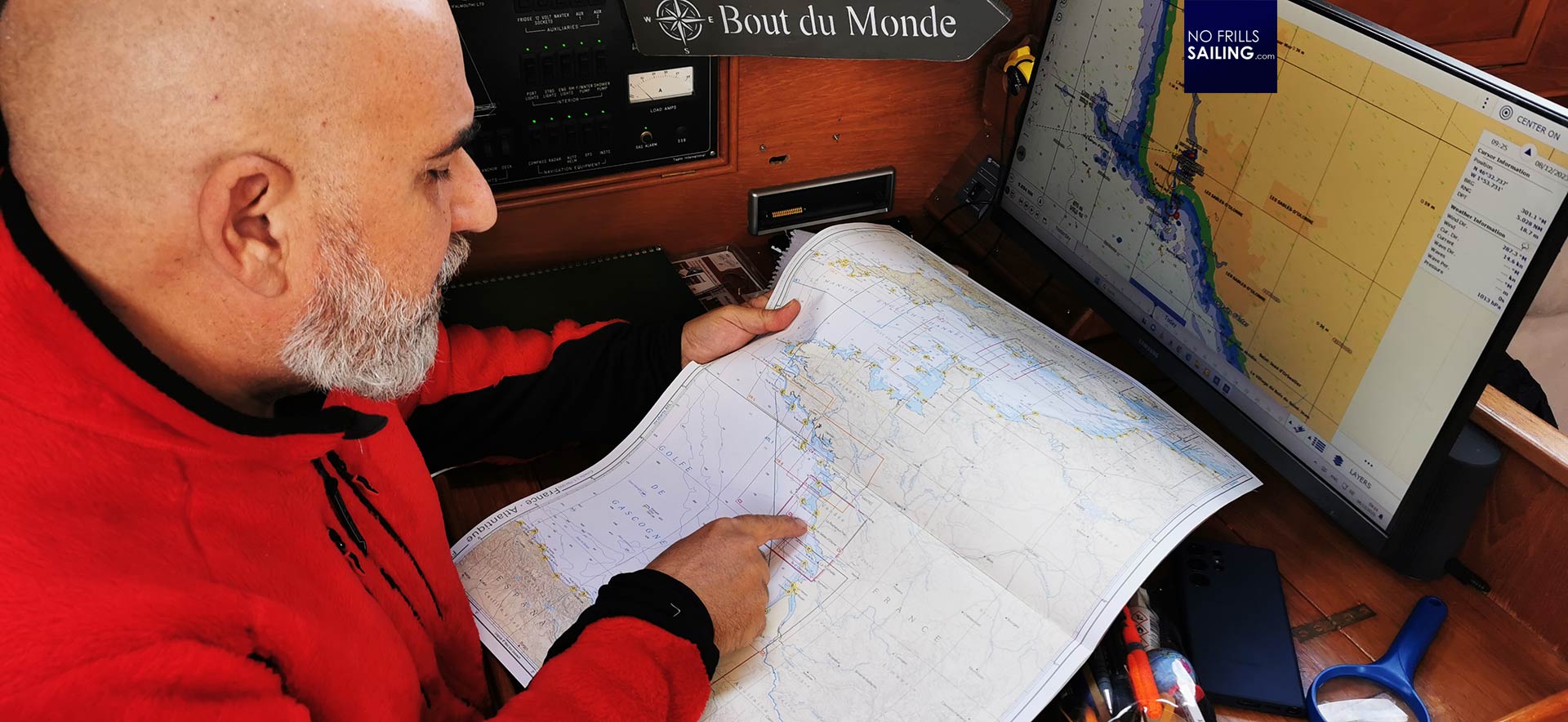
A small black box is installed right behind his rugged onboard computer (which itself is redundant too). This is the Iridium Go-installation, I´d say the gold standard for decades in marine and offroad offshore communication. Andrea will install the Starlink-antenna in a short matter of time too, which would achieve much more redundancy. “But first”, he says: “We´ll have it the classic way.” He smiles and takes out a navigational paper chart.
Back to old-school: Chart navigation
Andrea Lodolo is the holder of an official marine grade he earned by attending the British Merchant Navy´s program. Having had the education and examination to earn the rank of a Third Officer, of course, traditional and foremost professional navigation is a topic he has mastered with flying colors. I lean back sitting on the steps of the entryway´s ladder and think to myself: “Now, let´s look how a pro is doing it …”
“The Biscay is a treacherous area”, Andrea starts, “Heavy waves, strong winds and mostly a Westerly which is creating a dangerous lee shore situation most of the time. It´s good to be prepared and to know what will come – always! No matter if this is just a quick dash out or a longer leg as part of a big cruise.” I cannot agree more: Latest weather data and the knowledge of the region one is sailing in is the starting point.

“What I always do first, maybe in a corner of the chart, is to draw a vector that represents the general wind direction apparent.”, says Andrea and reads off a wind direction from his refreshed Time Zero weather routing software. The vector is now clear: “Well, everybody know his boat. There are points of sails and courses in relation to the wind that the boat will not be able to sail.” That is valid for any boat when it comes to the upwind “dead zones”, but many boats also have a dead zone in their rear.

“My Rustler don´t like running downwind. She will gobble and wobble most of the time so that this is not a stable or safe course. In this, I draw the limiting vectors to the wind-arrow.”, says Andrea and does accordingly. “Now, with one simple look, I can see very easily where we can go … and where we can´t go.” At least directly, I add.

He nods. But smiles: “As you can see, if we´d for example go to the Northern tip of the Ile de Ré, this would perfectly be possible starting here in Les Sables”, he says. This is a nice little trick, I think to myself, to start a navigational planning session. Something I always do back in my head: Surely any sailor know how many degrees to the wind he can push his boat and which courses are best for her to sail stable and quick, now getting confirmation by a trained and certified Third Officer is a nice little extra.
Confirmation, not definition
Having plotted a course to the Northern tip of Ile de Ré, Andrea takes out his dividers and checks for the distance – this is something we all have learned in the first lessons of the basic sailing certificates we all passed. Seeing this done by him with such an amount of dedication and time, makes me think. He has all any skipper is dreaming about aboard his ship: Fast internet, premium account with Time Zero, Iridium and such … but he still invests time to get his information the old-school way.

“I use the electronics for confirmation”, Andrea says: “Not for definition.” Relying solely on digital data can be treacherous like the Biscay waters too. Andrea also has to train for his participation at the Golden Globe Race-ventures in two years: No electronic equipment will be allowed by then. Just a Sextant, some charts and rule of thumb, when it comes to the prediction of the weather.

It takes just a handfull of seconds for the computer to calculate the best course. Andrea has put in the general data of his Rustler 36 first, like the polar diagram and basic measurements, sail area and such. By that, the software arranges the fastest and safest course to Ile de Ré – this time it does not differ from Andrea´s handmade route plotted on the paper chart.
Casting off for his adventures
It is just a small detail and for most of you maybe a banality. I myself haven´t thought about route planning much in the past time as it became a matter of fact prior to casting off. Checking weather and wind latest the day before the start of the trip and observing the general weather with a low zoom factor in Windfinder.com – by that I get the big picture and an ide of what is to expect within the next few days and also a pretty accurate prediction of the “high zoom” local area around me, what to expect within the coming 24 hours.

But this is Baltic Sea sailing, I guess: A relatively small sailing area, not very deep, surrounded by shores within a reach of a few hours sailing. Maybe sailing like this is good there, but it´s definitely something different sailing the Atlantic Ocean off Les Sables, especially now in late December. As we cast off for our little Ile de Ré sailing adventure, this little nice episode of route planning will be saved in my brain until now, coming out and manifesting in form of this article. A nice little story about a man who is 100 per cent connected to the internet at any time and any location – but still utilizes the good old pencil, ruler and dividers for route planning.
Also quite interesting articles:
Old school route planning with navigational charts
Weather routing with free software
Planning the kid´s first real big sailing trip